Real Terrain Capture Technology
(Drone + LiDAR Technology)
3D Geographic/Geologic Data Capture
HATS’ terrain surveying system, EagleMapper, offers two advantages. You can digitally scan and manage the terrain of the entire site that changes as the work progresses. It also measures the shape of the complex blasting target terrain as it is, stores it in a database, and uses it as basic data for effective blasting design. It increases the blast efficiency because it utilizes the actual terrain.
Key Feature
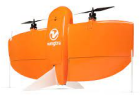
Fixed-wing Drone
· Capturing Mine Basemap.
· Update The progress and status of mines.
Rotary-wing Drone
· Acquire geo-information on individual blasting areas..
· Utilize basic data for blasting design.
Benefits
Accuracy improvement
· Provide actual topographic data to the EagleFineWeb, EagleDesigner
· Improve blast pattern design and work accuracy.
Additional service
· Regular analysis of changes in mining topography
· Control and prediction of blasting production in the area
· Analysis/Monitoring of slope stability
Unmanned topographic survey
· Replacement of surveying by manpower, reduction of labor costs, and improvement of accuracy.